Local
Three storms, nearly 3 feet of snow: Park City’s super El Niño winter starts tonight! | TownLift
A Roundtable is a way to meet new people and discuss this article in person at a local coffee shop or other venue.
Roundtables are designed for groups of four, with a shared subject and room for everyone to speak. Come for discussion, with no dating expectation.
Source: TownLift Park City
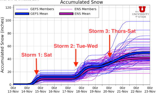
First storm begins tonight with a blast of 4-8" for the Wasatch Mtns. - over 3 feet of snow possible by the end of next week PARK CITY, Utah – The first in a series of three winter storms begins this evening with a cold front moving in through mid-morning on Saturday. Expect to see some light showers beginning tonight ahead of the front. The main bulk of snow, which looks to be in the 4-8” range in general for the Wasatch, will fall overnight through about noon on Saturday. A brief period of northwest winds could help the highest elevations of upper little cottonwood see closer to a foot of snow, although that is in the upper range of the forecast. This is by far the warmest storm of the three in queue and accumulations may be limited due to this, along with possible periods of graupel.
This excerpt comes from the named source. Read the original for the full reporting.
Read the original at TownLift Park City